I knew last week that I had the day off today for going hill walking, but until Sunday did not know for sure where that walk would take me. I had been in conversation with fellow walkhighland member Pollyh33 during the week, as we tried to get together for a walk that neither of us had done previously. When this did not work out as intended we agreed to settle on Schiehallion, as Polly had not done it and neither had Jelly McBaby, with a view to doing our next Munro together one that Polly has done and I have not (most probably Beinn Ime).
I have previously climbed Schiehallion on three occasions...once with Asima in 2006 (my first time) then with Baino and Barnett in July 2007 after the Lawers group the previous day (poor Bob never made it out of the car, claiming that we had burst him doing five the previous day) and lastly with Mhairi in 2008 on one of the hottest days of that year...but this would be my first time in the snow (and without a view unfortunately).
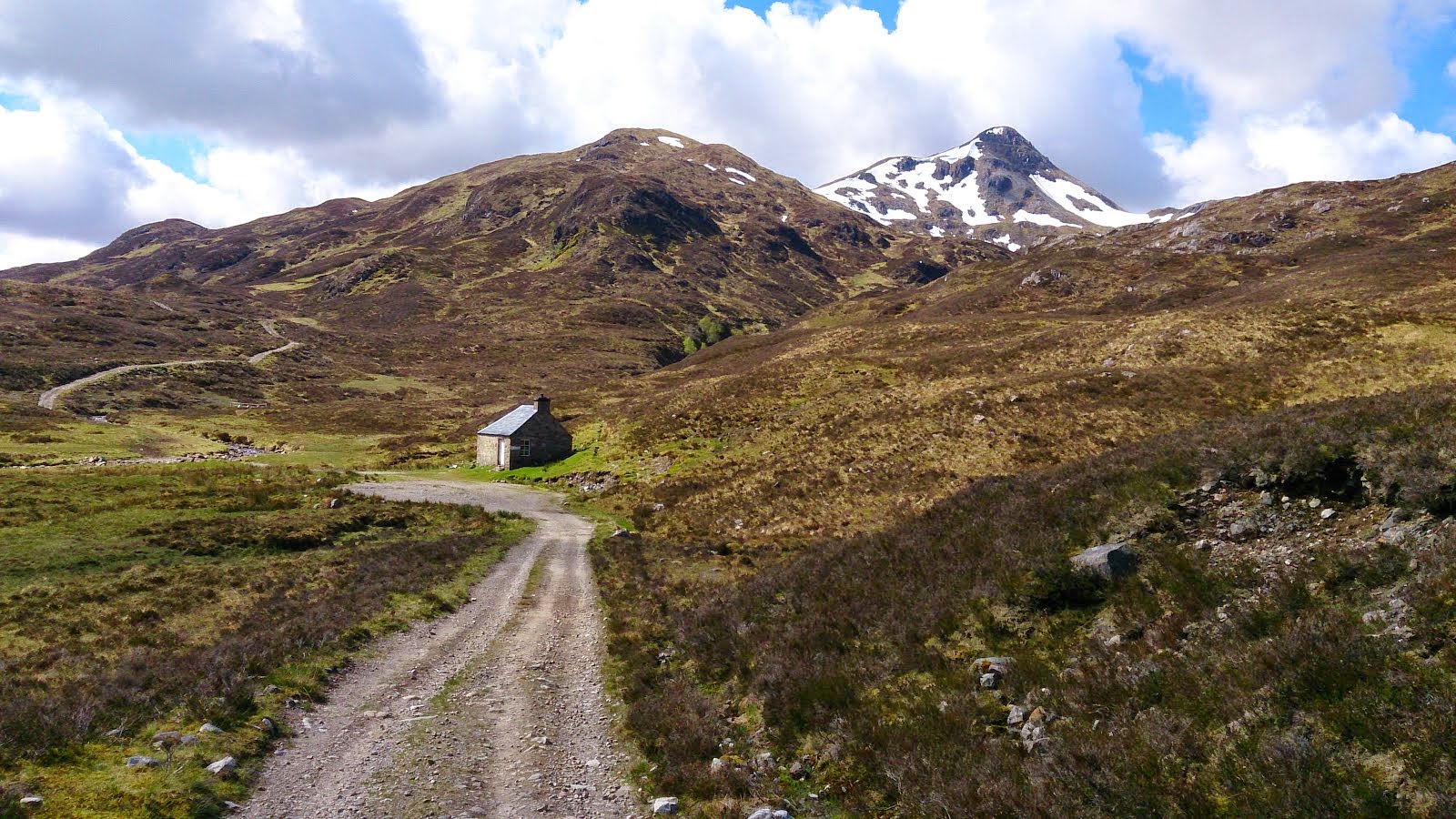
Schiehallion is one of my favourite mountains, ranking at 59th in the Munro table at 1083m, and is visible from many other Munro's around the country due to it's isolated location and conical appearance from the west.
Schiehallion's isolated position and regular shape led it to be selected by Charles Mason for a ground-breaking experiment to estimate the mass of the Earth in 1774. The deflection of a pendulum by the mass of the mountain provided an estimate of the mean density of the Earth, from which its mass and a value for Newton's Gravitational constant G could be deduced. Mason turned down a commission to carry out the work and it was instead coordinated by Astronomer Royal, Nevil Maskelyne. He was assisted in the task by mathematician Charles Hutton, who devised a graphical system to represent large volumes of surveyed heights, later known as contour lines.
Part of the mountain was also purchased by the John Muir Trust in 1999 and a renovated path was built, due to previous erosion of the old path, which now leads to the base of the east ridge.
It is also claimed that Schiehallion is the centre of Scotland. The justification is that the line of latitude midway between the most northerly and southerly points on the Scottish mainland, and the line of longitude midway between the most easterly and westerly points, intersect very near the summit of Schiehallion.
Phew, enough of the science geek bit and on with the walk!!!
We met up at the Braes of Foss car park (agreed for ten, but I will forgive the tardiness on this occasion) following a strange journey down (BLOODY SAT NAV WOMAN!!!!) and were ready to go by half past ten.
The mist was swirling thick around the flanks of the mountain and visibility was going to be little or nothing at all further up (it ended up being nothing at all).
The new path is as good as I remembered it to be and we made good time along it as we chatted away about a variety of subjects (hills, equipment, food) and before we knew it we were already climbing up the frozen steps almost a third of the way in.
Just ahead of us were an older couple that had passed me in the car park whilst I was waiting patiently...They stopped for a brief blether then headed off again across the first patch of snow on the way up. They stopped again to let us pass as they had decided to only go as far as the ridge then return.
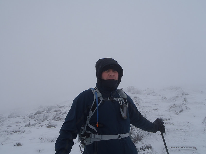
We pressed on into the worsening conditions, wind whipping up the loose snow around us, mist getting thicker with each step. The path was mostly obscured by snow, those parts that poked through were frozen solid and slippy.
Each turn seemed to take us face on into the wind, the temperature felt like it had really dropped as our rucksacks, jackets, hats and gloves all started to freeze up.
I recognised a small cairn on the route, encased in rime ice, from previous visits. Slightly further on from there a small stone shelter sits on the path, usually a good protection from the wind, but was full of snow and ice. Around this point I decided enough was enough and I needed the extra protection of my hardshell to keep out the worst of the chilling wind. Cheers to Polly for holding my sleeve for me or I would have struggled against that wind for ages before getting my arm through...

The wind seemed to kick up another notch as we battled into it, heads down and hoods pulled tight, the snow thickened beneath our feet as we stepped out of rocky areas on the flanks of the east ridge, then thinned out again as we again stepped through large boulders beneath us. I was having trouble seeing anything in front of me...including my GPS screen (which all looked blank against the brightness of the snow) so decided to put on my new goggles (which I had reluctantly bought after slagging Spot (Andy) off on a previous trip in November)...what a godsend they proved to be!! From everything looking/feeling blurry around me as the snow made everything look white and shapeless I suddenly had clarity of vision. Now I could make out shapes of rocks and see the edges of the corrie to my left. They also help keep the worst of the wind off my face...but I do look a balm in them, of that there is no doubt!!
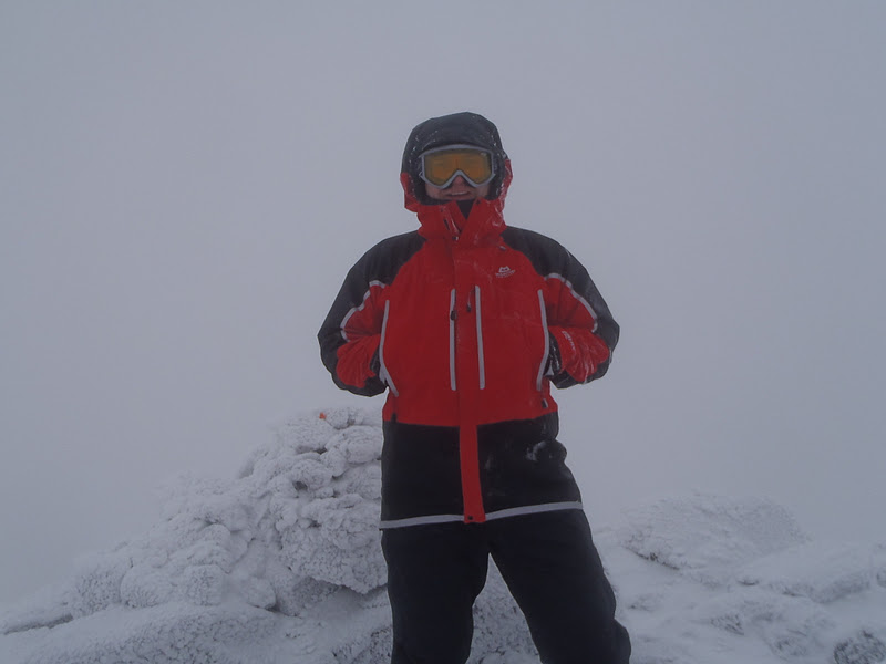
We picked our way along the remainder of the ridge, up through the boulders and were soon on the summit ridge itself...which we picked our way along carefully as there is a massive drop off to the left and the cairn sits right on the edge of it.
Once at the summit I got Jelly McBaby out of my frozen rucksack and positioned on the icy cairn.
A few pics taken it was time for a bite to eat...custard and ginger cake from my flask...then a slice of Mum's cake for energy (shared with Polly) and then off as quick as possible before my fingers froze solid!!
Poor Polly already had frozen hair sticking out of her hat...
The return plan was to follow our footsteps back, though this proved harder than envisaged as the wind had already eradicated most of them!! On the way off the summit we met another couple coming up, looking every bit as frozen as us.
The mist seemed even thicker on the way back down and visibility was poor.
The wind was at least at our backs now and I think it helped to blow us down a bit quicker, though I was stopping constantly to check our position for fear of wandering too far to either side in the whiteout.
Eventually the path returned beneath our feet and as we made our way off the hill the weather cleared enough to let us take a few pics.
Care was taken on the return path, more so lower down than higher up, as the steps were like a skating rink!! We returned safely to the car just in time for a brief flurry of snow to descend on us. Polly got the tangfastics out (horrible fizzy sweets) and we said our farewells until the next time...
I thoroughly enjoyed my fourth trip up the fairy hill of the caledonian's...even without the views of previous trips...and will happily return again and again no doubt before I'm done.
SatNav lady tried to catch me out again on the journey home but I was having none of it this time...I can see her getting replaced!!!
Until next time folks...if you consume pink cocktails on a Saturday night do not be surprised when your pee is still pink on the Monday!!!
I had been hoping to meet up with a couple of guys from WalkHighlands today but for various reasons they were unable to join me. Putting aside my disappointment at that I set off on my own anyway. As is my preference, I travelled down the night before walking (Tuesday), and stayed local. I booked into the Village Inn in Arrochar and arrived, via a scary drive along the A82 in pitch black and rain, around half five. I spent a relaxing night in bed watching DVD's and sorting through my route for the morning. An early night beckoned and I hoped this would leave me refreshed for the morning...Unfortunately my body had other ideas and at half one in the morning it decided to reject the prawn wrap I had consumed earlier for tea...!!!
I had a terrible night, not ideal preparation for a walk the following day, and still felt rather delicate when I awoke at seven (I even contemplated binning the walk and going home as a result). I skipped breakfast, didn't want to run the risk of a repeat performance, and hoped that a banana would settle my stomach and allow me to get something productive done today.
I settled my bill and apologised for my reclusiveness and promised to return and sample the hospitality on offer (the food smelt divine when I arrived and so did the breakfast when I was leaving) some time soon.
It was a five minute drive from the Inn to the start point, the car park in Succoth, and another five minutes saw me ready to take a risk on walking whilst feeling under the weather.
I had company as I was getting ready at the car, a little robin was hoping for some crumbs but I had nothing to give it.
I crossed the road and headed for the start of the walk, up through the forest walk access gate leading to Beinn Narnain and the Cobbler.
I hung a sharp right at the first bollard and was straight into a strenuous ascent of the hillside, crossing a path further up and continuing to climb...almost 660m before getting a slight respite at a flat section of boggy ground...although the views were worth every ounce of pain in my weakened state.
I was happy to stop and take little breathers as I was snapping away at Loch Long...Ben Lomond (with Loch Lomond beneath it) and any other hill I could see on the way.
Beyond this flat boggy section there is a path rising straight up the face of Cruach nam Miseag, culminating at 813m, and a few scrambly sections as the path rises through rocks, quite narrowly at times. The wind had picked up by this point and there were some violent gusts buffeting me about as I picked my way up through the rocks (if my arse wasn't twitching before it certainly was now!!).
Another flatish bit of ground, and a decent view of the Cobbler, then straight up again through patches of hardened snow amid the rocks.

There was one section I came to where I stepped onto the snow just as a blizzard swirled round me, not thinking I should perhaps adorn my micro-spikes, and as I was halfway across it I realised that it was a long way down if I were to slip (the snow was packed hard and quite icy and at a rather severe angle down onto some rather jaggy rocks a fair way below and my ice axe was safely in the boot of my car) but thankfully I made it across safely as the wind was picking up again and making visibility at this stage rather difficult as it was blowing hail around me. A short scramble across some wet rocks (5p 50p 5p 50p all the way) then a last pull up some frozen scree and eventually I was up top and only needed to locate the summit...if I could stand up long enough!!! The wind was brutal by now and really painful to fight against...then as quickly as it had whipped up it subsided again...and it was a short walk up to the triangulation point and summit cairn at 926m. As I was bending over, rummaging in my rucksack for Jelly McBaby, I got a start as two other walkers appeared beside me (I couldn't hear them for the wind). They had set off from the car park just after me but had erred on the cautious side and avoided the scrambly section in favour of following the 'tourist route' along to the base of the Cobbler and coming up the back of Beinn Narnain.

We exchanged greetings, as best we could in the conditions, and I got a pic of McBaby on the trig point.
I battled against the wind across the summit plateau to drop down the rocky path off Beinn Narnain towards Beinn Ime.
I had been warned that this route is very boggy on the ascent to Beinn Ime but was hoping that the worst of it may still be quite frozen.
I reached the bealach a' mhaim in good time and started to climb the hillside...my hope for frozen paths through the worst of the bog didn't exactly pan out...and continued onwards and upwards until the wind worsened to the extent that I literally could not keep going.

I was standing with my back to the hill as gusts were hitting me like body blows and the hail started again (turning to snow the higher up I got) until eventually it was a full on blizzard and whiteout conditions. I hunkered down for five minutes hoping that the worst of it would pass and I could continue...I was at 900m now, only 200m short of the summit that I could see so clearly only minutes ago...another half an hour would have seen me at the summit and back off again...but not against this wind!!! It killed me to be so close yet have to turn round...but I knew it was the sensible thing to do in the circumstances. I had hardly eaten a thing all day (a banana before setting off then some jelly babies at the first summit) and felt too weak to fight on any longer. My legs were actually shaking as I started to turn and head downhill, I needed to get something inside me for energy and had the very thing. Knowing that this would be a custard free day I had planned ahead and taken a couple of slices of jamaican ginger cake (custardless is not as good) with me...oh they so needed tanning now!!

As I returned to the bealach the weather on Beinn Narnain and the Cobbler started to clear...but not behind me on Beinn Ime.
Once at the bealach I followed a faint path through the bog toward the Cobbler, where it joins onto an excellent access path running beneath the Cobbler and all the way back to the car park at Succoth.
I stopped briefly when I came to the Narnain Boulders...two HUGE pieces of rock on the lower path that must have made quite a "gdoosh" when they landed there!!
I followed the path back and took a pic of the Cobbler, and planned to return and do it along with Beinn Ime in the next few weeks...I was back at the car five hours after leaving it...knowing that it would only have taken me another half an hour at most if I had summitted Ime.
Just as I arrived at the car the rain came on and didn't let up...one last slap from mother nature before I left!!
Until next time (which hopefully won't be too long) stay safe and continue reading xx
I had hoped to be away climbing a Munro today, but a combination of being late shift yesterday and feeling too tired to get up REALLY early to drive anywhere ruled this out. I then contemplated a day of lazing around, interspersed with an attendance at the gym, but knew I would feel guilty about not doing anything outdoors...and there is only so long I can stay on a treadmill before I get bored!!
So I decided that I could have a lie in then go up Bennachie, thus giving me my outdoor fix for this week, and still be home in time for tea. Bennachie is made up of a number of different tops, across a number of rises over a vast area of land beyond the small town of Oyne in Aberdeenshire. The highest top is Oxen Craig at 528m and the most strikingly noticable top is Mither Tap 518m (which can be seen from miles away in many directions). There are a number of different access points onto Bennachie also, with at least four different car parks scattered around the base of the hill. Today I started from the 'back o Bennachie' car park, just in off the Oyne road beyond Archeolink. The path starts from the signpost in the car park (which explains all the different routes around Bennachie and some of the wildlife you may be lucky enough to spot).

It winds up through some trees and crosses another path (the circular route around the hill) before disappearing into the trees again and climbing steeply for a short distance.
Once through the trees the path continues to climb up above the tree line and soon opens up views across the arable land to the north of Aberdeen. The higher you climb the better the views, especially on a clear day. From this route the first top I reached was little oxen craig...where there was an interesting information board about it's use as a quarry.
I scrambled onto the top of it and took a few pics, including one of a rather noisy bird sitting below me.
I noticed a few other folk out walking from my vantage point (I think I saw another eight people on the path at various times throughout my walk), all taking their time and enjoying the dry weather. From little oxen craig I made my way along the zig zag path towards Craigshannoch, another of the main prominant tops.
The temperature dropped slightly and I was forced to stick my hat on, but it was still calm with very little wind. One thing I did notice was how dark it appeared in some of the pics, though it was only midday it did appear to be getting more overcast as I progressed.
I continued on my way along the vastly improved path (it was regenerated a few years back and is now in better condition than parts of union street!!), onwards and upwards to the Mither Tap.
I managed to get some atmospheric looking shots of Mither Tap outlining a mean looking sky...pretty impressed with myself and my camera today.
From the summit of Mither Tap I got some good views down to Glen Clova and out towards Aberlour (Ben Rinnes).
I stopped for a spot of lunch (chicken legs today) and found another information board to read...I never knew that the summit of Mither Tap had been the site of a Pictish fort.
I then carried on to Oxen Craig, the highest point on Bennachie. As I meandered along the winding path the temperature dropped even further and it was numbing my hands as I walked, so I stuffed my camera away for a while, at least until I reached the next summit, and warmed my hands inside my jacket.
When I reached the top of Oxen Craig the wind picked up and I really felt the cold biting into me.
I got a few more pics then headed off along the path and down the hillside...back along till I reached the access path and then followed it back down through the trees and eventually back to the car. Once back at the car it was time for some pea and ham soup from the flask to heat me up...no cake and custard today...then the twenty or so miles drive back to Aberdeen.
All in I was on the hill for three hours today and felt far happier than I would have down the gym...fresh air rules!! Hopefully next week I will manage back on a Munro on my day off...but if not then perhaps I will try Ben Rinnes for size??
A low level reminder of what I find so beautiful and appealing about the Cairngorm national park...My intention was to revisit an old walk today at Cairnwell (the three Munro circuit above the Glenshee ski centre) which I first did a few years ago with Chris and Mark in beautiful summer weather.
Recently I have been all about walking new Munro's, bagging summits, visiting new locations, meeting new people to walk with...and today would have been no different if the weather forecast wasn't so bad and I had stayed somewhere overnight to get an early start without a long drive. As it happened I had hoped for company today but others wanted to do the whole weekend and I didn't feel like it (for once). So off I set this morning heading to Glenshee with the intention of taking Jelly McBaby up a route he had not previously been on with me. However, the first problem of the day was when I arrived at Glenshee to find it absolutely hoaching with skiers...a full car park as well...everywhere I looked they were there. Not one for crowds I opted to u-turn back to Braemar and head out to Linn of Dee instead. I decided to walk along Glen Derry for as far as I could in the conditions (wet and blustery) and set myself a target of enjoying my day out regardless of how far I got or what the weather did.
After parking up in Linn of Dee and paying the ticket machine (which I almost forgot) I set along the trail through the trees, crossing the slatted wooden concourse, up through more trees then onto the path proper.
When I started walking Munro's back in 2006 my first few adventures were in the Cairngorms, along this very path, which I grew to hate with each trip along and back. Such is the length of the walk in to any Munro in this area that you are always faced with a long walk back afterwards...it can be soul destroying after walking and climbing for anything up to ten hours on some routes...every step back along the path from Derry lodge to Linn of Dee would be felt as though my legs were ready to drop off.
And as it's the main route into the Cairngorms you are left with no alternative but to walk it more than once (unless you fancy a long weekend camping out on summit plateaux to bag them all together).
The main difference today, except that I haven't done it since 2010 (Derry Cairngorm with Mark and Chris), was that today there would be no target to reach at the other end, meaning I felt less intense walking along the path and could enjoy it for what it is...an excellent access path to one of the best areas in Scotland.
As I headed in along the path towards Derry Lodge the weather reminded me of why I wasn't up a hill today...blustery swirls of rain battered against me and I pulled my hood tighter and my buff higher on my face. The path was quite slippery with ice and had a fair amount of snow on it in places, not what I was expecting at such low level. The summits that I could start to make out through the blizzard above them were covered in snow, unlike so many other areas recently, the Cairngorms holds onto its winter covering sometimes well into the summer months.

As I approached Derry Lodge I could start to make out Carn Crom through the swirls of sleet and snow, rising high above the lodge across Luibeg burn...temptation almost took me across the bridge towards it...but I resisted and stayed on the right bank of the burn and followed the rising path along Glen Derry, leaving the lodge behind. Derry lodge is a fine looking building that is unfortunately boarded up permanently. It is owned by the NTS and in my opinion more use should be made of such facilities.
This is yet another fine path that gives access to Beinn a'Chaorainn and Beinn Bhreac on the right side of Glen Derry and fine views of Derry Cairngorm's sloping flanks along to Carn Crom on the left of the Glen. The path rises to a height of approx 515m before turning downhill again...it is at this point that you would head off to your right and follow a faint path through the trees, if you were heading for Beinn Bhreac.

But I followed the path down in front of me as I continued on my merry way (merry and wet and cold) to wherever I felt like stopping and turning back. With the time I was taking to trudge through thick snow (even at this low level) I calculated reaching not much further than the last bridge across Luibeg burn before having to about turn and head back. There were plenty of deer tracks along the path, but no sign of any deer. There were a few sets of old boot prints, complete with crampons (the tell tale marks in the snow give it away)no less, heading along the track as well, surely from this morning as opposed to yesterday.

As I dropped down into the Glen again I could barely make out anything in the distance, when I had been hoping to make out Beinn Mheadhoin and the slopes curving around Derry Cairngorms lower reaches at the very least. I could see the start of the deer fences, erected to protect the new saplings from ravenous deer, but not much else beyond that. The wind was picking up, the sleet was getting wetter and I was getting colder...Brrrrr time to head back me thinks.
So I crossed the bridge over the burn and followed the path back on the other side of Luibeg burn...what a mistake that was!!
The snow was even thicker at this side and no-one had been through it in days (if at all) so I kept plunging through to freezing cold puddles beneath the surface as I followed the path back.
I forgot that the path on this side follows closer to the burn so would naturally be wetter than the higher one I took out...but at least the trees were thicker and provided more protection from the elements above (except all the ones that Mother nature had toppled over in a strop...PMT me thinks!!).
I trudged back along to Derry lodge, crossed the wooden structure carefully (vibram soles and wet wood don't go well together) and took a slight detour off route to Bob Scott's bothy.
My first trip into this area was with Asima and a few others doing the Lairig Ghru in 2006, where we spent a night camping out at the bothy. We even built a camp fire and toasted marshmallows, as well as a perfectly good pair of socks that got just a little too close to the flames when I tried to dry them out whilst still wearing them (oh you live and learn).
This only left the last walk back to Linn of Dee from Derry lodge to go...the source of much suffering previously was a canter today. I passed a few other walkers on the way, a young family whose kids were already fed up of peddling bikes so the Father was left pushing them along, and a couple of lads dressed for the arctic but without any packs on.
The red bridge (not it's actual name, though I don't know why) was crossed and the last leg was upon me...time for some last minute reflection...before I made it back to the car and my flask full of custard and ginger cake. A lesson learned this morning regards contents of flask...always use full fat custard, as opposed to the low fat alternative, as the low fat one thins out as it cools and leaves a mushy mess in your flask...it was almost drinkable rather than spoonable when I eventually opened it!!!

It doesn't matter what your preference is; crampons or microspikes, walking poles or ice axe, bladder or bottle, map and compass or GPS, soft shell or hard shell...the list goes on...these are just some of the material things that we use to help us get from A to B safely and in comfort on the hills...What is really important to remember is that the most undervalued asset at our disposal as we tackle all of these challenges before us is passion. Without passion we wouldn't set foot out of the car and head into some of the weather we experience across this beautiful country of ours, be that rain, snow or heatwave (we each have our own preference for walking in) as we strive to achieve happiness from one of life's simple pleasures (and something that we all take for granted at one time or another). People talk about battling against all the odds to make it to a summit...but I prefer to think that we embrace rather than battle...we embrace the challenge set before us and hold onto all the fond memories we collect along the way, even the bad days are used to mould into experience to use on the better days when everything goes our way.
As I passed the halfway mark of Munro's last year I started to think about targets for the year ahead and also about where I would like to do my final Munro, if I make it that far, and in a way I now feel that I lost sight of what is important to me (from a hill walking perspective). It matters not that I do them all (though it would be a nice achievement) but that I get out and do them at all. I love this country of ours (from a natural beauty perspective) and want to continue travelling around it, seeing every part of it at least once, meeting new people to walk with and share my adventures along the way.
I hope that by continuing this blog I encourage some to share my passion for the hills (even vicariously) and perhaps even to come join us and experience it for themselves just once...you never know you might just become as hooked as me...Until the next time folks...happy wandering x